This page illustrates one or two of the local routes that can be pursued starting and finishing at Leathley Parish Rooms.
Riffa Woods Short
Easy Pace: 1 hour.
Moderate Pace: 45 minutes.
From the parish rooms, head downhill off the village green for just 20 metres, walk for a few yards in front of the almshouses, then fork right through the gateway leading off Stainburn lane.
The drive is known as Riffa Lane. Follow this drive past Leathley Hall and beyond, avoiding the right fork to Pool, continuing along the path which becomes rougher and in places boggy.
After climbing alongside a slightly sunken section, go through a gate at the top of the hill and continue along the grassy track which follows the top of the slope. Riffa Woods comes into view after less than a mile.
After a number of gates, you reach the last field before the Riffa Woods. (*) Turn left, following the leftmost boundary and avoiding the crossing of Riffa beck, then follow the rather rutted and tree-lined track which eventually comes out on Stainburn Lane. Turn left and follow the road back to Leathley.
This route is shown by heading anticlockwise round the yellow highlighted loop below:
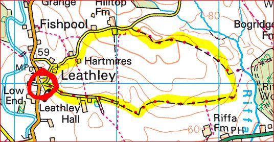
Riffa Woods Medium
Easy Pace: 1 and a half hours.
Moderate Pace: 1 hour.
Extend the previous walk by going from (*) diagonally across the field to reach the ‘stepping’ stones across Riffa Beck and thence into the woods, where bluebells abound in Springtime. Enjoy, then return back across the beck but bear up the right hand side of the wire fence to join the shorter route in a matter of minutes.
Farnley Church and Lindley Bottom
Easy Pace: 2 hours.
Moderate Pace: 1 and a half hours.
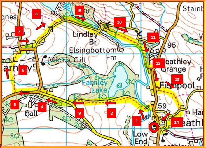
(1) Follow the main road over the brow of the hill past the church.
After 200 yards take the footpath to the left across a field, to a wooden bridge.
(2,3) Follow the path which uphill to the bend in the road near Farnley.
(4) Take care as you follow the road right as far as the junction at the centre of Farnley village.
(5) Continue along the road towards Otley for just 100 yds and take a footpath to the right
(6). Take this path across fields towards Farnley church.
(7) When you reach the road, turn right and then turn left at the bend down a minor road.
(8,9) The road winds down a steep hill and after about 3/4 of a mile you come to Lindley bottom, where a trout farm occupies a space which many years ago used to be one of the most delightful picnic spots in all of the valley.
(10) Cross the old stone bridge and then turn immediately right to follow a footpath along the old mill goit. Keep within sight of the river, as you negotiate a sadly delapidated boggy section (11), finally emerging onto the B6161 at the site of the former Leathley corn mill.
(12) Turn right along the main road (care needed). Take the footpath over a stile to the left after 200 yds, which if you follow your nose (13) takes you over some small rises and dells to Stainburn lane.
(14) Turn right back to the village hall.
Farnley Long
Easy Pace: 3 hours.
Moderate Pace: 2 and a half hours.
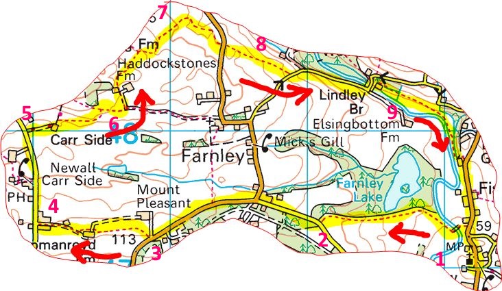
(1) Follow the main road over the brow of the hill past the church. After 200 yards take the footpath to the left across a field, to a wooden bridge. Follow the path which uphill to the bend in the road near Farnley.
(2) With care, follow the road right keeping straight on at the junction at Farnley.
(3) Shortly before the road bends left, take a footpath leading diagonally across a field to your right. Follow this footpath across numerous stiles and then along a farm track which emerges onto the Otley-Blubberhouses road.
(4) Turn right. Stop at the pub on your left for refreshments if required. Continue another 200 yds until a rather formidably gated drive is seen to your right.
(5) Signpost or not, this is indeed a footpath which veers left to go past the left of some buildings. A pleasant rising path takes you up to join a second footpath and across a cattle grid onto a surfaced track.
(6) Turn left along a track towards another farm, but at the next bend branch left cross a couple of stiles and veer right diagonally across a field.
(7) Climb two more stiles in a rather hairbrained route that was diverted a few years ago. The general direction is soon downhill towards the reservoir, then bending increasingly round to the right. Eventually you will reach a stile onto the B6451. Cross straight over the road.
(8) A boggy section prevails, heading diagonally downhill following the line of the fence, to join the minor road from Farnley. The road winds down a steep hill and after about 3/4 of a mile you come to Lindley bottom.
(9) Cross the old stone bridge and then turn immediately right to follow a footpath along the old mill goit. Keep within sight of the river, as you negotiate a sadly delapidated boggy section, finally emerging onto the B6161 at the site of the former Leathley corn mill. Turn right along the main road back to the village hall.
Stainburn Round
Easy Pace: 3 hours.
Moderate Pace: 2 and a half hours.
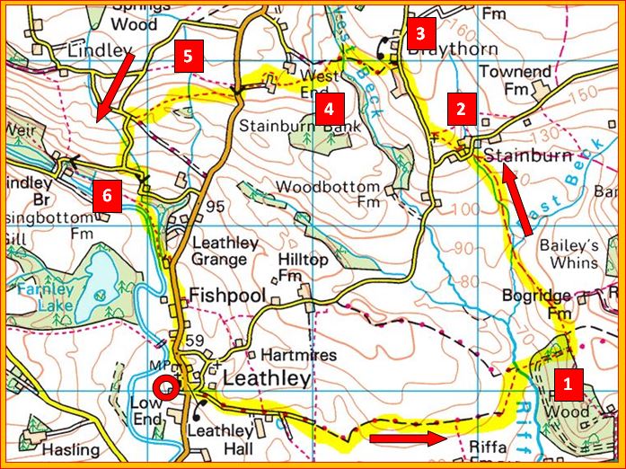
From the parish rooms at Leathley, follow Riffa lane past Leathley Hall avoiding the right fork to Pool. Continue until Riffa Woods is reached after negiotiating a crossing over Riffa Beck.
(1) At the top of the ancient track through Riffa Woods, turn sharp left and follow a variable track for a good half mile to the hamlet of Stainburn.
(2) Turn left along the road for just a hundred yards and then take the footpath leading uphill at the very next bend, to follow a lovely path through Stainburn Churchyard, and turn right at the next road.
(3) At Braythorne, turn left between two sets of buildings, down a tree-lined gully which is rocky and slippery.
(4) After crossing the bridge across West Beck, continue uphill along the unmaintained ‘Byway’ which at the best of times is rough going, until a stile is reached to the left (easily missed). Head diagonally uphill. After negotiating a diverted section round the farm with numerous gates and stiles, you will eventually emerge on the B road at the top of Leathley Bank.
(5) Taking care to negotiate the traffic, turn left downhill, but almost immediately seek a very hidden stile to your right as you start to descend the steepest part. The next section of the walk, though not clearly marked, is delightful as it descends gradually in roughly a straight line across three fields and stiles to reach a lane. Careful navigation is called for!
(6) Wend your way down the road and turn left at the T junction. You reach a sharp right and then a sharp left hand bend round the corner of a house. A few yards further on there is footpath acccess through a gate down past interesting mill goit workings to the main riverside footpath, which you can follow as far as the road and from there follow the road back to the centre of Leathley.
Technical Notes
Reproducing these maps was by no means a straightforward process. Various methods were employed (as the visitor will notice!). The latest method was that the maps were 'snipped' from the Maps4Free website, using the highlighting tool to highlight in yellow and pen tool to draw the arrows. Paint.net was used to draw the numbers.